Indoor Navigation
Indoor Navigation
In indoor environments without GPS, the Pangolin AT-1 relies on SLAM technology to achieve autonomous navigation. SLAM technology enables the robot to simultaneously build an environmental map and localize its own position within an unknown environment using sensor data (such as LiDAR, cameras, etc.).
LishoPilot provides three indoor task modes: “SLAM,” “Simultaneous Localization and Navigation,” and “SLAM and Navigation.” The “SLAM” mode is primarily used for constructing environmental maps and localizing the vehicle; the “Simultaneous Localization and Navigation” mode is mainly used for autonomous navigation within a known environmental map; and the “SLAM and Navigation” mode combines the functionalities of the former two, enabling both map construction and autonomous navigation in unknown environments.
SLAM (Simultaneous Localization and Mapping)
To achieve accurate indoor navigation, it is recommended to first construct an environmental map before using the Pangolin AT-1 for indoor navigation. The Pangolin AT-1 supports multiple SLAM algorithms, allowing users to select the most appropriate algorithm for map building and localization based on actual requirements.
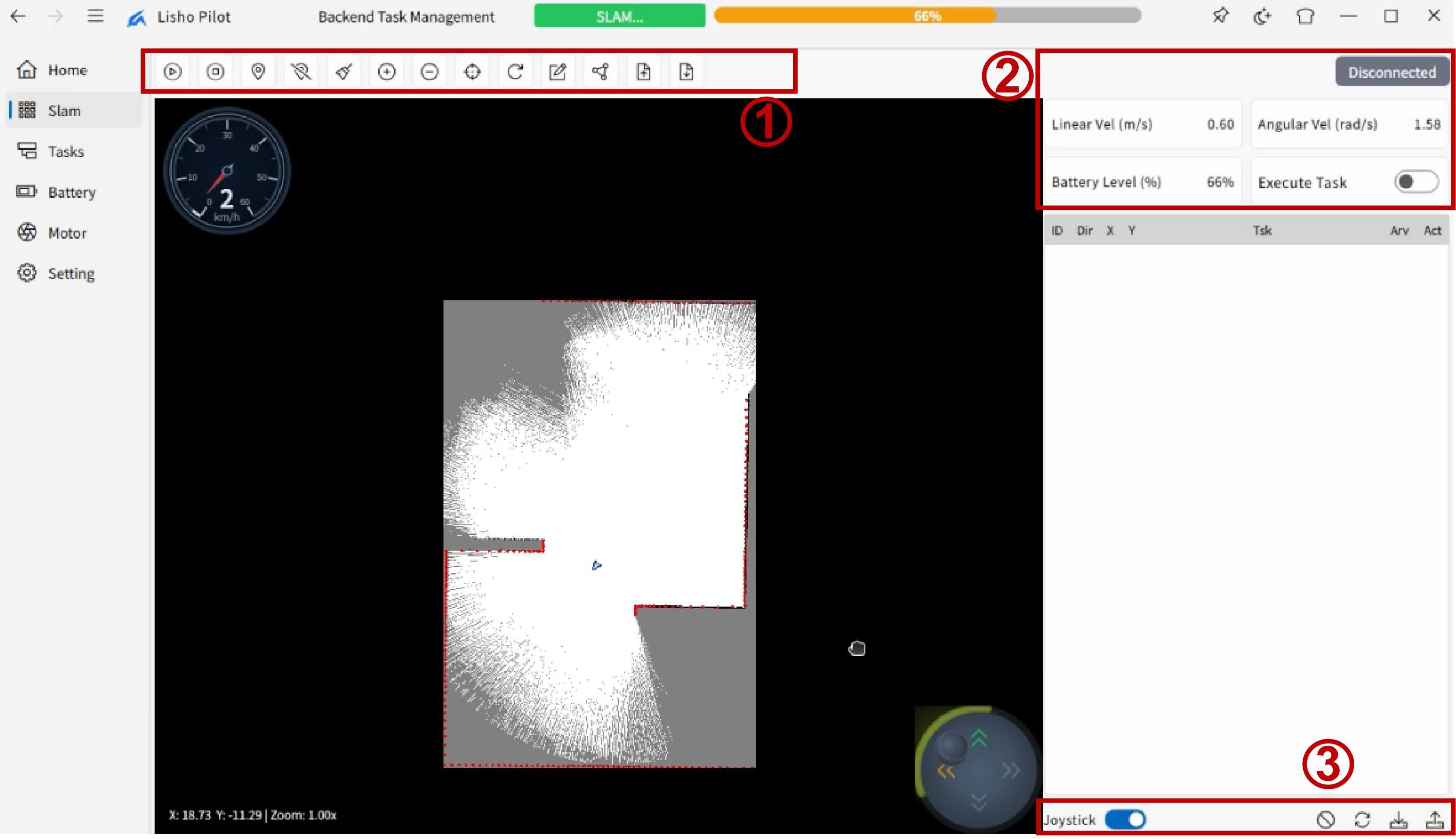
As shown in the figure, the main area of the “SLAM” interface is the central map region, where users can enable the joystick display feature and control the vehicle's movement via the joystick to complete the entire map construction. In addition, the interface includes three functional zones for users to edit and save tasks, among other operations.
Function Zone 1
This zone is the primary functional area, containing key functions such as starting and stopping navigation. Listed from left to right:
- Start Navigation: Click to begin the current navigation task.
- Stop Navigation: Click to immediately stop the current navigation task.
- Select Waypoint: Users can click on the map to add new waypoints.
- Delete Marker: Deletes waypoints or area markers that have been added to the map.
- Clear Markers: Clears all waypoints and area markers on the map, including the vehicle's driving trajectory.
- Zoom In: Users can zoom in on the map for a clearer view of the vehicle's real-time position, orientation, trajectory, waypoints, and more.
- Zoom Out: Users can zoom out on the map for a broader view of the vehicle's real-time position, orientation, trajectory, waypoints, and more.
- Initialize Pose: Users can click this button to re-initialize the vehicle's pose for more accurate navigation and localization.
- Reload: Users can click this button to reload the current map in order to update map information or restore the map state.
- Map Editing: Users can click this button to enter map editing mode for modifying the map. The specific functions are as follows:
- Eraser: Users can use the eraser tool to erase impassable areas on the map.
- Brush: Users can use the brush tool to draw impassable areas on the map.
- Line: Users can use the line tool to draw straight lines on the map.
- Route Planning: Users can click this button to plan traffic routes accessible to the vehicle as non-free-form planned routes:
- Add Node: Add a new node to the planned route.
- Add Directed Edge: Add a new directed edge to the planned route.
- Delete Node: Delete a node from the planned route.
- Delete Directed Edge: Delete a directed edge from the planned route.
- Clear All: Clear all nodes and directed edges.
- Hide/Show Route: Hide or show the planned route.
- Import:
- Import Map: Import an existing map file.
- Import Route: Import an existing route file.
- Export:
- Export Map: Save the current map as a local file.
- Export Route: Save the current route as a local file.
Function Zone 2
- Liner Vel: The vehicle's linear velocity, indicating its horizontal movement speed, measured in meters per second (m/s).
- Angular Vel: The vehicle's angular velocity, indicating its rotational speed, measured in radians per second (rad/s).
- Battery Level: The vehicle's battery level, indicating the remaining charge, measured as a percentage (%).
- Excute Task: Task execution toggle button. When enabled, the vehicle will automatically execute the corresponding task upon reaching the target point.
Function Zone 3
The auxiliary function zone contains four buttons and a joystick control show/hide toggle, where the joystick control can be used to directly control the vehicle's movement. The other four buttons, listed from left to right, are as follows:
- Deselect: Click to deselect the currently selected row in the table.
- Restore Default State: Click to restore the arrival status and task execution status of all waypoints in the table to their default state, i.e., “Pending.” This operation does not affect the waypoints' direction, latitude/longitude information, or associated tasks.
- Export Task: Click to save the current navigation task as a file for subsequent loading and execution. The saved task file can include waypoints, area settings, task associations, and other information, allowing users to reuse it across different scenarios.
- Import Task: Click to load a previously saved navigation task from a local file. The imported task file will overwrite the current navigation task settings; users are prompted to confirm before proceeding to avoid accidental data loss.
Simultaneous Localization and Navigation
After completing SLAM map construction, users can select the “Simultaneous Localization and Navigation” mode to perform autonomous navigation on the known map. In this mode, the vehicle uses the previously constructed map for localization and moves autonomously according to the waypoints and routes set by the user.
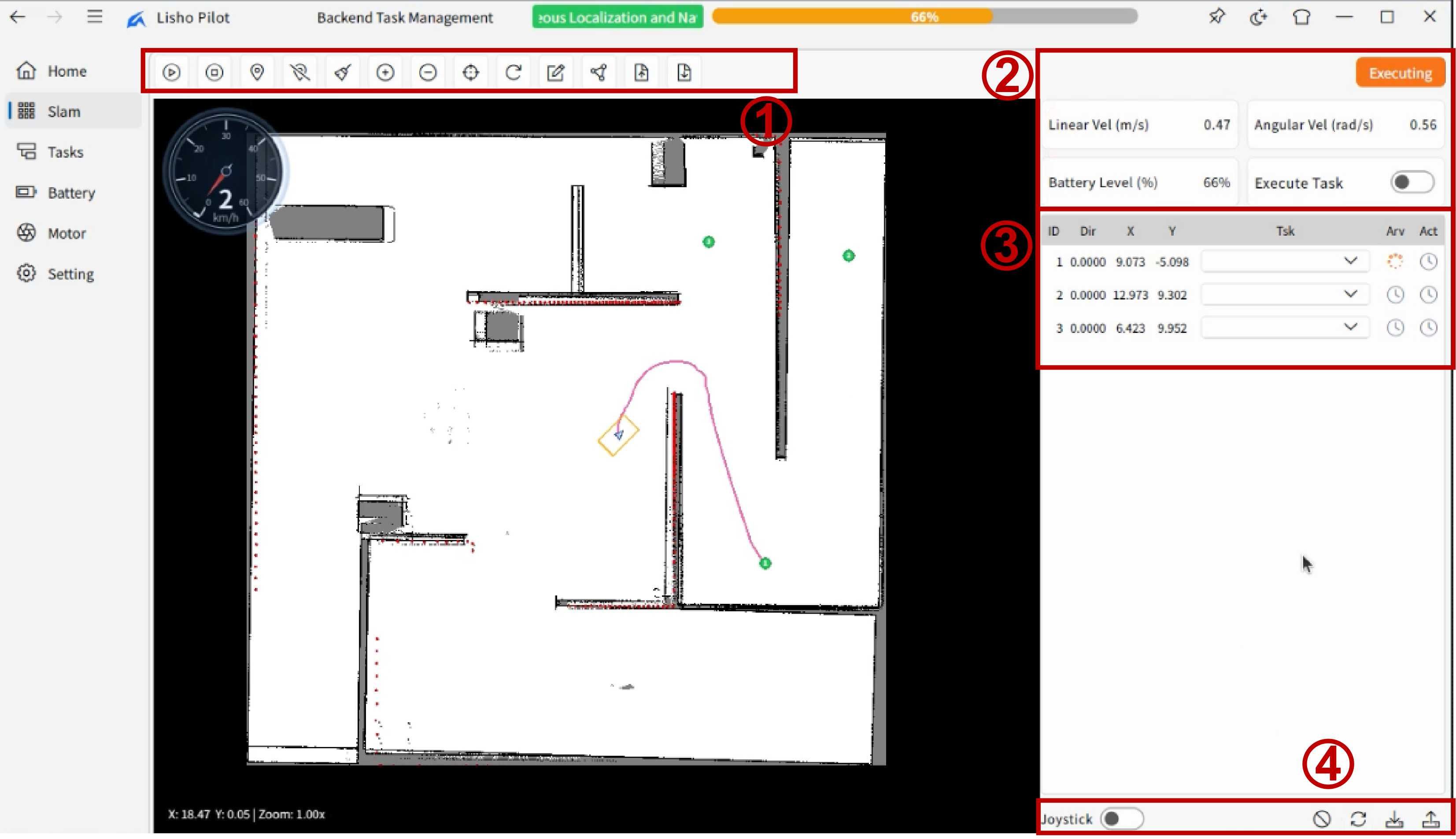
The overall interface layout is similar to that of the “SLAM” mode, with the main area still being the map region. Users can directly control the vehicle's movement via the joystick control. Compared to the “SLAM” mode, this mode adds waypoint and task execution functionality. Users can click on the map to add new waypoints and configure their arrival status and associated tasks in the table on the right. Upon reaching a waypoint, the vehicle will execute the corresponding operation based on the user-defined task (similar to the functionality of “Outdoor Navigation”).