Outdoor Navigation
Outdoor Navigation
In outdoor environments, the Pangolin AT-1 achieves global localization via RTK and combines sensor data from 3D LiDAR, IMU, and wheel odometry to enable autonomous navigation and obstacle avoidance. Users can activate the “GPS navigation” task from the top of the LishoPilot terminal, allowing the vehicle to drive autonomously in outdoor settings. The navigation task supports multiple modes, including point-to-point navigation, path following, and area coverage, to meet the needs of various application scenarios. Below are the main features and operating instructions for the Pangolin AT-1's outdoor navigation.
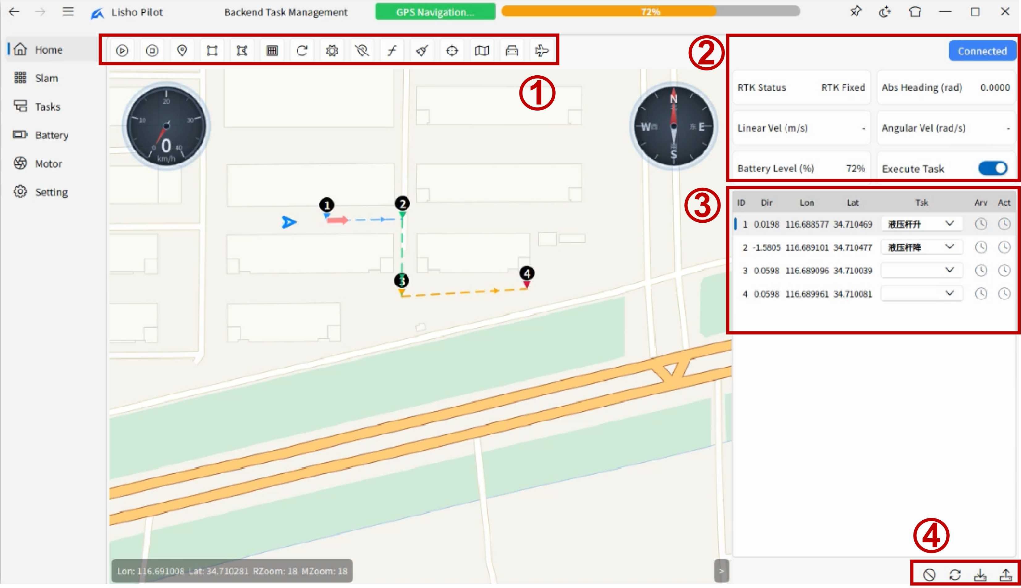
As shown in the figure, the main area of the “GPS navigation” interface is the central map region, which primarily displays the vehicle's real-time position, orientation, trajectory, waypoints, and more. In addition, the interface includes four functional zones for users to edit and save tasks, among other operations.
Function Zone 1
This zone is the primary functional area, containing key functions such as starting and stopping navigation. Listed from left to right:
- Start Navigation: Click to begin the current navigation task.
- Stop Navigation: Click to immediately stop the current navigation task.
- Select Waypoint: Users can click on the map to add new waypoints.
- Draw Quadrilateral Area: Users can click on the map to draw a quadrilateral region for defining a specific driving range or work area (depending on the “Area Function” button).
- Draw Polygon Area: Users can click on the map to draw a polygonal region for defining a specific driving range or work area (depending on the “Area Function” button).
- Area Function: Users can toggle the purpose of the area via this button, such as setting it as a driving range or work area — for example, a no-go zone, an operational zone, or a farm coverage operation mode.
- Refresh Start Point: The start point refresh button for farm coverage operation mode. Clicking it recalculates the current start position.
- Set Origin: Users can click on the map to set a new origin position, which the vehicle will use as a reference point for navigation and operations.
- Delete Marker: Deletes waypoints or area markers that have been added to the map.
- Clear Trajectory: Clears the vehicle's driving trajectory drawn on the map.
- Clear Markers: Clears all waypoints and area markers on the map, including the vehicle's driving trajectory.
- Current Position: Click to automatically center the map on the vehicle's current position and display the surrounding environment.
- Map Type: Users can switch between different map types, such as satellite or street maps, for improved navigation and task planning.
- Vehicle Model: Users can switch between different vehicle model displays for a more intuitive understanding of the vehicle's position and orientation on the map.
- Navigation Mode: Users can select different navigation modes, switching between free route and fixed route to meet varying application requirements. In free route mode, the vehicle automatically plans a new path when encountering obstacles; in fixed route mode, the vehicle strictly follows the preset route and stops when encountering obstacles.
Function Zone 2
The top area displays the current navigation service connection status of the vehicle:
- Disconnected: The vehicle is not connected to the navigation service and cannot perform navigation tasks.
- Connected: The vehicle has successfully connected to the navigation service and is ready to perform navigation tasks.
- Executing: The vehicle is currently executing a navigation task; users can monitor the vehicle's driving status and position in real time.
- Succeeded: The vehicle has successfully completed the current navigation task and will stop and return to its initial state.
- Canceling: The vehicle is in the process of canceling the current navigation task, either due to manual user intervention or an emergency requiring task interruption.
- Canceled: The vehicle has successfully canceled the current navigation task and will stop and return to its initial state.
- Aborted: The vehicle encountered an abnormal condition during navigation task execution, causing the task to abort; the vehicle will stop and return to its initial state.
The lower area, listed from left to right and top to bottom:
- RTK Status:
- No Fix: Positioning invalid — the vehicle has not acquired valid positioning information.
- SPS: Standard Positioning Service — the vehicle obtains position via single-point positioning, with relatively low accuracy.
- DGPS: Differential GPS — the vehicle obtains position via differential positioning, with relatively high accuracy.
- Fixed RTK: Fixed RTK positioning — the vehicle obtains position via fixed RTK, offering the highest accuracy, suitable for high-precision navigation requirements.
- Float RTK: Float RTK positioning — the vehicle obtains position via float RTK, with relatively high accuracy, though lower than Fixed RTK.
- Estimating: The vehicle is estimating its position; accuracy may be degraded due to unstable signals or other factors.
- Manual: Manual input mode — the vehicle's position information is entered manually, typically used for testing or special scenarios.
- Simulator: Simulation mode — the vehicle is navigating in a simulated environment and does not rely on actual positioning information.
- Pseudo-range: The vehicle obtains position via pseudo-range measurements, with relatively low accuracy, typically used for assisted positioning or testing.
- Abs Heading: The vehicle's absolute heading angle, indicating the angle relative to geographic east, measured in radians (rad).
- Liner Vel: The vehicle's linear velocity, indicating its horizontal movement speed, measured in meters per second (m/s).
- Angular Vel: The vehicle's angular velocity, indicating its rotational speed, measured in radians per second (rad/s).
- Battery Level: The vehicle's battery level, indicating the remaining charge, measured as a percentage (%).
- Excute Task: Task execution toggle button. When enabled, the vehicle will automatically execute the corresponding task upon reaching the target point.
Function Zone 3
This zone primarily displays detailed information for each waypoint and task in a table format. The table contains the following columns:
- ID: The unique identifier for the waypoint, used to distinguish between different waypoints.
- Dir: The direction information for the waypoint, indicating the vehicle's heading angle upon arrival at the waypoint, measured in radians (rad).
- Lon: The longitude of the waypoint, indicating its longitudinal position in the geographic coordinate system, measured in degrees (°).
- Lat: The latitude of the waypoint, indicating its latitudinal position in the geographic coordinate system, measured in degrees (°).
- Tsk: The task information associated with the waypoint, indicating the task content to be executed at that waypoint (tasks must be added in advance on the Tasks page).
- Arv: The arrival status of the waypoint, indicating whether the vehicle has successfully reached the waypoint. Includes three states: “Pending,” “Running,” and “Completed.”
- Act: The task execution status of the waypoint, indicating whether the vehicle has successfully executed the associated task at the waypoint. Includes three states: “Pending,” “Running,” and “Completed.”
The direction and latitude/longitude information of waypoints in the table can be edited directly (for direction, select the row and drag to adjust on the map), or by dragging the waypoint on the map with the left mouse button. For each row, users can right-click to delete the row or change the waypoint's arrival and task execution status. The arrival status and task execution status are automatically updated based on the vehicle's actual operation and do not require manual modification. Each time a navigation task is executed, the vehicle automatically filters out completed waypoints and only processes unfinished ones, ensuring task continuity and efficiency.
Function Zone 4
The auxiliary function zone contains four buttons:
- Deselect: Click to deselect the currently selected row in the table.
- Restore Default State: Click to restore the arrival status and task execution status of all waypoints in the table to their default state, i.e., “Pending.” This operation does not affect the waypoints' direction, latitude/longitude information, or associated tasks.
- Export Task: Click to save the current navigation task as a file for subsequent loading and execution. The saved task file can include waypoints, area settings, task associations, and other information, allowing users to reuse it across different scenarios.
- Import Task: Click to load a previously saved navigation task from a local file. The imported task file will overwrite the current navigation task settings; users are prompted to confirm before proceeding to avoid accidental data loss.